
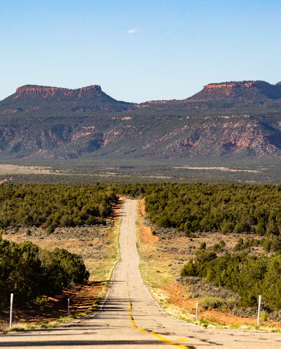
Tucked deep into southeastern Utah’s wild backcountry lies one of the most fascinating and overlooked places in the Southwest, Bears Ears National Monument.
This is the kind of place many travelers unknowingly drive right past on their way to bigger-name parks like Arches National Park or Monument Valley Navajo Tribal Park. But Bears Ears rewards the people willing to slow down.
Here, you’ll find ancient cliff dwellings, hidden canyons, petroglyph panels, scenic drives, dramatic overlooks, and some of the most important Native American cultural sites in the country. It’s remote, rugged, and far less crowded than Utah’s famous national parks; which is exactly what makes it unforgettable.
As an Amazon affiliate, when you click on some of the links on this page and make a purchase, we may earn a small commission, at no cost to you! By using our affiliate links, you’ll find our favorite picks and support us at the same time. And we really appreciate your support!
If you’re looking for archaeology, epic desert landscapes, and a road trip that feels like a real adventure, Bears Ears National Monument belongs on your bucket list.
Why Visit Bears Ears National Monument?
Bears Ears is known for its remarkably well-preserved Ancestral Puebloan sites, making it one of the best places in Utah to explore ancient ruins and Indigenous history.
Travelers looking for archaeological sites in Bears Ears will find: Cliff dwellings, Kivas, Petroglyphs, Ancient Villages, Ceremonial sites, historic routes and cultural landmarks.
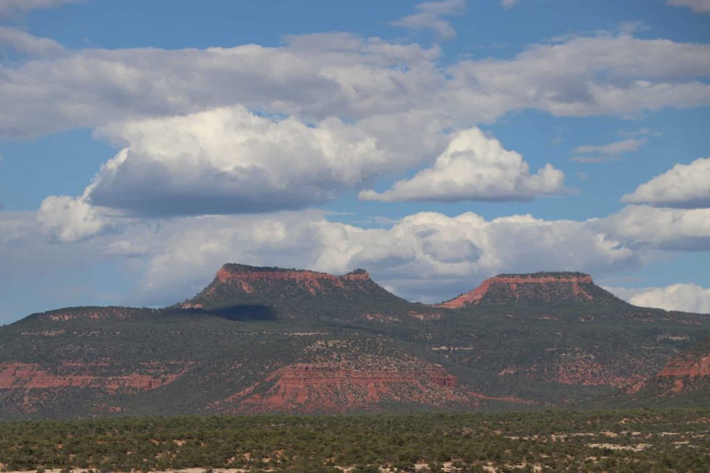
The monument is named after two prominent buttes that resemble bear ears rising above the landscape, and the entire region carries deep cultural and spiritual significance for many Indigenous tribes.
This is not just a scenic stop, it’s a place that deserves time, respect, and curiosity.
Short on Time? Here Are 3 Great Bears Ears Itineraries
Even if you only have a few hours, you can still experience some of the best parts of Bears Ears. These three easy itineraries help you plan your visit depending on what kind of adventure you want.
Scenic Drive Adventure
Best for: Big views, iconic overlooks, and classic road trip vibes
Start in Bluff with a stop at Sand Island Petroglyphs, then continue to Valley of the Gods, Goosenecks State Park, the famous Moki Dugway, and finish at Muley Point for sunset.
This route is one of the best scenic drives in southern Utah.
Pro Tip: Be sure you have plenty of space on your camera SD card because you will take lots of pictures. If you’re looking for a new camera that also takes great videos, we recommend the Kodak PixPro.
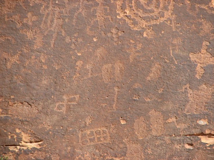
Sand Island Petroglyph Panel
This roadside panel features centuries of rock art dating back more than 2,500 years.
You’ll find carvings from the Basketmaker, Pueblo III, Navajo, and Ute cultures, making this one of the most accessible and impressive petroglyphs stops in the region.
Located inside Sand Island Campground, the area also has restrooms, camping, a boat launch, and seasonal ranger services.
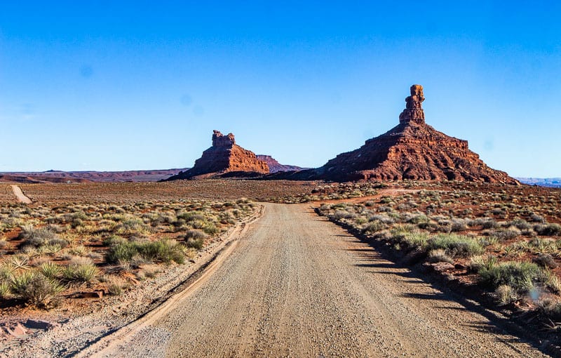
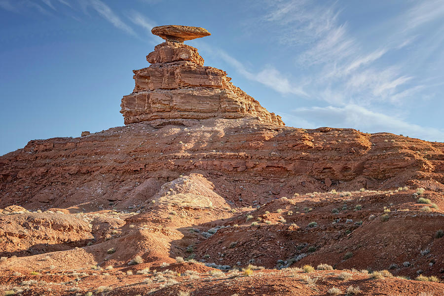
Valley of the Gods
Often called the “Mini Monument Valley,” Valley of the Gods is a 17-mile scenic drive through towering sandstone buttes and wide-open desert views. Located near Mexican Hat, this free drive is one of the best hidden gems in Utah.
The road is unpaved but usually manageable for passenger vehicles when dry, though 4WD is always a safer bet. Driving time is typically one to two hours.
Keep an eye out for Mexican Hat Rock, a famous roadside formation that really does look like a sombrero balancing on a rock.
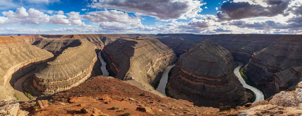
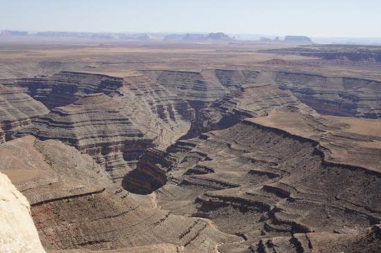
Goosenecks State Park
Goosenecks State Park gives you not one, but two dramatic horseshoe bends in the San Juan River.
From the overlook, you can see the river winding 1,000 feet below through deep canyon walls. It’s one of the most impressive quick stops in Utah and only about 10 minutes from Valley of the Gods.
There are vault toilets, primitive camping, and a small entrance fee.
Muley Point
If sunset had a favorite place, it would probably be Muley Point.
From over 5,700 feet in elevation, you get sweeping views of Monument Valley, Valley of the Gods, Navajo Mountain, and the San Juan River goosenecks.
There are no facilities here, so bring water, snacks, and your camera. Primitive camping is allowed, and it’s one of the best dispersed camping spots in southern Utah.
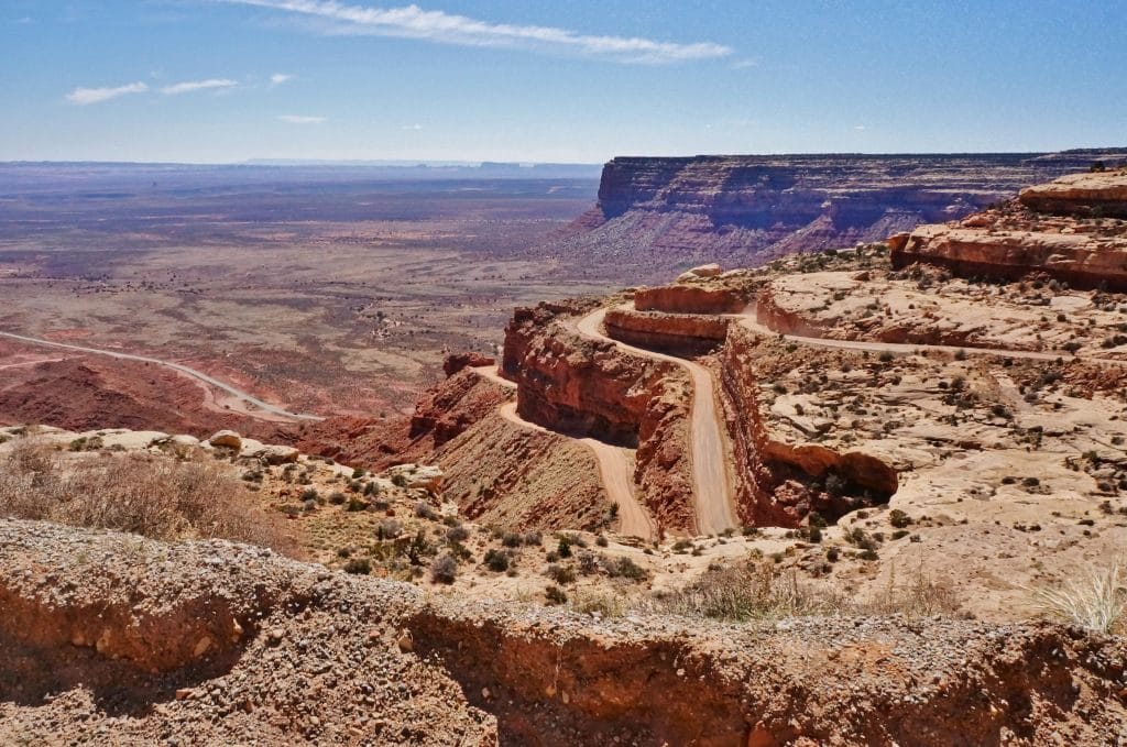
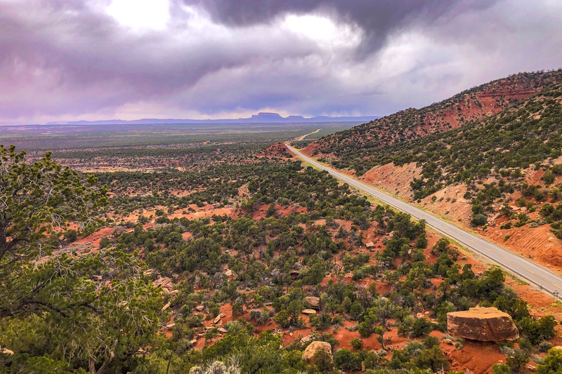
Moki Dugway
This road to Muley Point is part of the adventure.
Moki Dugway is a steep, winding set of dirt switchbacks carved directly into the cliffs. There are no guardrails, the grade is steep, and yes, it can absolutely make your palms sweat. Caution is an absolute.
High-clearance vehicles are strongly recommended. RVs are not.
It’s beautiful. It’s terrifying. It’s worth it.
Northern Bears Ears Excursion
Best for: Scenic overlooks and combining with Moab or Canyonlands
If you’re visiting Canyonlands National Park or staying near Moab or Monticello, this northern route makes an excellent day trip.
Take Harts Draw Road through the Abajo Mountains, stop at Newspaper Rock, and finish at Needles Overlook. This route has incredible views and very few crowds. There are no facilities or campgrounds.
Harts Draw Road
This scenic dirt road offers panoramic views of Bears Ears, the La Sal Mountains, Indian Creek, and the Needles District of Canyonlands.
At Harts Draw Overlook, sitting at 8,200 feet, the views are excellent and the cooler mountain air feels like a reward. Harts Draw Road is 42 miles.
This is a winding, dirt road that is generally in good condition. There are no services here, so pack food, water, and patience for dirt roads. The gravel pullout is ADA accessible.
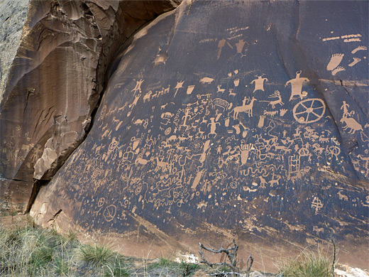
Newspaper Rock
Newspaper Rock State Historical Monument features more than 650 petroglyph designs spanning roughly 2,000 years of history.
Created by Ancestral Puebloans, Fremont people, Navajo people, and others, it’s one of the most significant rock art panels in the Southwest.
There’s a developed parking area, pit toilet, and easy roadside access.
Honestly, it’s the only newspaper you should stop for on vacation.
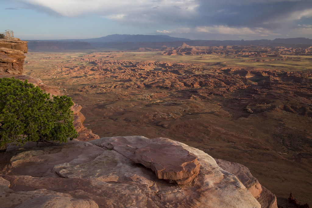
Needles Overlook
Needles Overlook sits 1,600 ft above the Needles District of Canyonlands National Park and offers nearly 360-degree views of the sandstone formations that line the view on the horizon.
The road is well maintained and has a parking area near the overlook. There are picnic tables, vault toilets, and plenty of reasons to stay longer than planned. So, pack a lunch and enjoy the views. It’s worth it to enjoy the view and relax.
Cultural Immersion Tour
Best for: Ancient ruins, archaeology, and Indigenous history
Take the scenic Trail of the Ancients Scenic Byway and stop at Butler Wash, Mule Canyon Kiva, Salvation Knoll, and the Kane Gulch Ranger Station.
This route offers some of the best archaeological experiences in Bears Ears.
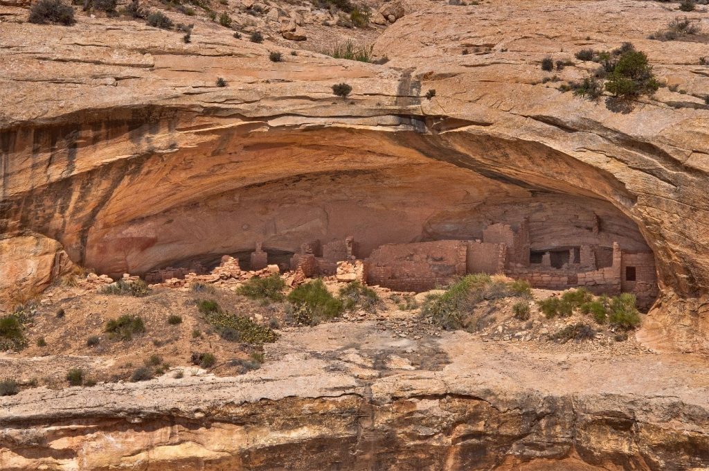
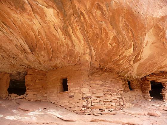
Butler Wash Overlook
This one-mile round-trip trail leads to a stunning overlook of Ancestral Puebloan cliff dwellings dating back to around 1200 CE.
From the mesa-top viewpoint, you can see multiple structures used for living, storage, and ceremonies. It’s one of the best easy hikes in Bears Ears.
There is a large parking lot equipped with a toilet and plenty of parking space for larger vehicles and RVs.
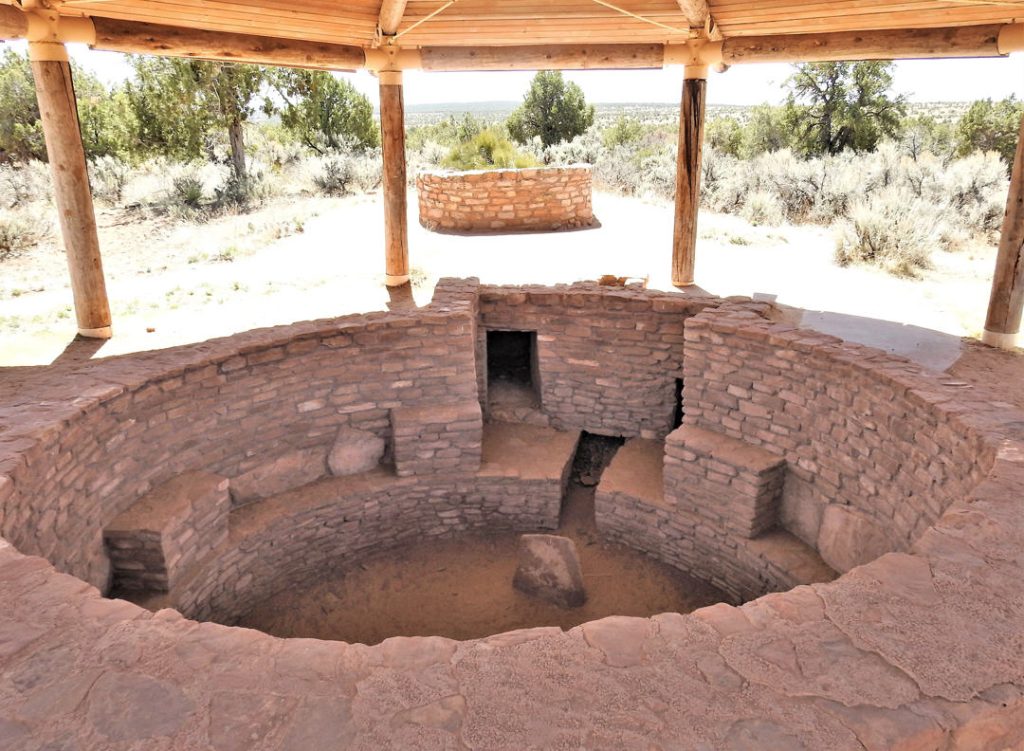
Mule Canyon Kiva
This roadside stop offers a rare up-close look at an excavated kiva and nearby surface structures built by the Ancestral Puebloans over 700 years ago.
The Mule Canyon Ruin parking lot has a restroom and shaded area, but no picnic tables or other facilities. The site is handicap accessible.
It’s accessible, educational, and one of the easiest major cultural stops to visit.
Salvation Knoll
This short but steep half-mile hike leads to an interpretive site about the Mormon Hole-in-the-Rock expedition of 1879–1880. From the top, you get the same sweeping views early settlers once used to plan their route west.
The trail is rugged and climbs 170’, use care while hiking on the slippery gravel. There are no restroom facilities available at Salvation Knoll.
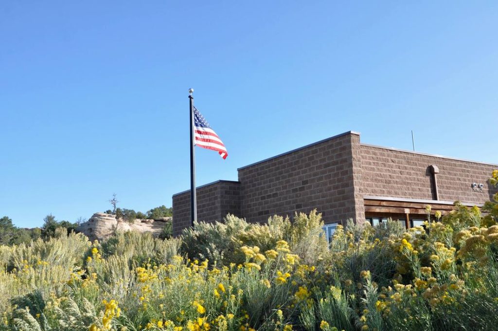
Cedar Mesa Rock Imagery Exhibit
Located at Kane Gulch Ranger Station, this exhibit helps explain the layers of rock art and cultural history throughout Cedar Mesa.
Hours vary seasonally, so check ahead before visiting.
It’s a great final stop to better understand everything you’ve been seeing on the trails.
Visit Bears Ears With Respect
This landscape is not just beautiful, it is sacred. It deserves respect.
Ancestral Puebloans lived here between 700 and 2,500 years ago, and many of their homes, farming areas, and ceremonial sites remain incredibly well preserved.
A few important rules:
View sites from a distance which show respect to the area.
Leave all artifacts where you find them, this includes fossils and bones. Don’t touch or try to use ancient tools. Even if something looks like it doesn’t belong, leave it where it is.
Don’t touch pictographs or petroglyphs. Absolutely do not try to add one of your own.
Stay away from walls as structures are fragile and can be easily damaged.
Don’t bust the crust – stay on existing trails and routes to avoid damaging soil. Use rubber-tipped hiking poles and stay on designated roads and paths.
Dogs and archeology don’t mix. There are some places in Bears Ears National Monument that leashed dogs are allowed, but never near fragile archeology sites.
Camp and eat away from archeological sites. Pack out all garbage and toilet paper. Never burn in these areas.
Basically: take photos, leave absolutely everything else alone.
Bears Ears Partnership has a comprehensive etiquette guide that is helpful to understand these rules. You can read it here.
Pro Tip: Whenever you’re exploring nature and ancient sites you should always follow the Leave No Trace guidelines.
Read More: Preserve the Wild: A Simple Guide to Leave No Trace for all Outdoor Adventures
Things to Know Before You Go
Bears Ears is remote, and planning ahead matters.
A few important things to keep in mind:
Cell service is unreliable or nonexistent. Be sure someone knows what your plans are.
Gas, groceries, and trash disposal are only available in nearby towns. Be sure to bring plenty of water with you, the desert can dehydrate you fast.
Emergency services can take hours, or longer. Consider carrying an emergency kit with you. You may be able to fix what is wrong to at least get to town. This one from Everlit even has a first aid kit with it.
Many trails are unmarked and require navigation skills. Be sure to have paper maps with you and consider a GPS Navigation system if you’re going to be hiking. We like this one from Garmin.
Road conditions vary wildly depending on weather. Check the weather before you leave.
Flash floods are a real danger in canyon areas. Flash floods are no joke, don’t take chances.
4WD and high-clearance vehicles are strongly recommended for many routes. Before taking an RV make sure the road will accommodate it.
This is not the place to “just wing it.” Planning ahead and being prepared for the unexpected will make for a less stressful trip.
Bring water. Bring extra fuel. Bring a backup plan.
Final Thoughts
Bears Ears National Monument is one of the most rewarding road trips in Utah. You can spend a few hours hitting the highlights or spend an entire week exploring hidden ruins, remote canyons, scenic drives, and some of the most culturally significant landscapes in the Southwest.
It’s quieter than the major national parks, richer in history than most people realize, and full of the kind of views that make you pull over every ten minutes.
If you want a Utah adventure that feels wild, meaningful, and a little less crowded, Bears Ears is exactly where you should go.
We love sharing tips and information we learn along the way to help you plan your next trip. We hope to inspire you to find your adventures, have lots of fun and make many memories.