
On our way back from Mesquite, AZ we decided to go to the Valley of Fire State Park. Valley of Fire is Nevada’s oldest and largest state park. This amazing park is just 50 miles northeast of Las Vegas. The address is 29450 Valley of Fire Highway Overton, NV. It has something for everybody from hikers to nature lover’s and is a must see for adventure lovers. Here’s everything you need to know before visiting this extraordinary park.
This post includes some affiliate links. If you make a qualifying purchase through one of these links, we will receive a small percentage of the sale at no additional cost to you. Thanks for your support.

History of Park
Some history on the Valley of Fire. The park is 40,000 acres of bright red Aztec sandstone nestled in gray and tan limestone. Ancestral Puebloans lived in and around the park over 2500 years ago as discovered by the petroglyphs found in the valley. The park opened in 1934 and officially designated Valley of Fire State Park in 1935. The park derives its name from the way the red sandstone formations appear to be on fire when the sun is setting. These were once sand dunes back in the dinosaur days. This land was once covered by the sea and as a result, you can still see limestone and find petrified wood.
Basic information
The park has two entrances, east and west both on Valley of Fire Road. The entrance fee is $10 per vehicle for Nevada residents and $15 for non-residents. Be sure to pick up a map at the entrance as it gives lots of information and helps with navigation in the park. The park is open year-round, from sunrise to sunset. The visitor’s center is open 9 AM to 4 PM daily. Spring and Fall are good times to visit, just wear layers as it will heat up as the day goes on. Winter is also a good time to visit when the highs are in the 60’s, however days are shorter then so keep that in mind when planning your trip. Some hiking trails are not open mid-May through the end of September because of the desert heat. It is least crowded in the morning, so try to get there early. You will be given a map when you pay your entrance fee to help plan where you want to go in the park. If you plan to camp, it is $20 per night for residents of NV and $ 25 for non-residents. There are two campgrounds with a total of 73 sites and one group camping area with 3 sites. You must make reservations as they fill up quickly. For more information visit the park’s website.

Rules and regulations
It is illegal to remove or damage any rocks, minerals, artifacts, etc. from the park. This includes moving rocks that are in a path or tampering with the petroglyphs. It is also illegal to remove or disturb animals or plants. Do not climb on arches or walls especially those with petroglyphs. Please help to preserve the park and petroglyphs by not touching anything. Only walk on designated paths.
Camping is allowed only in the camp sites. There are picnic areas around the park with tables if you want to take a break and grab a bite to eat, some of these do have charcoal grills you can use. There aren’t any places in the park to buy food or drinks so make sure you are well supplied. Pets are allowed as long as they are on a leash no longer than 6ft.
Drones and RC aircraft are not allowed. If you want to do commercial photography, you must get a permit. You need to apply for this at least 6 weeks in advance.
Driving the Park
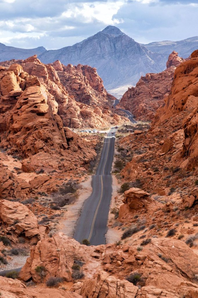
If you’ve read some of our other articles, you’ll know that we are not big hikers, so we only went to the places where there were pull offs. But you can still see many of the attractions here by driving the two roads here. Valley of Fire Road and White Domes Road (also known as Mouse Tank Road). I’m going to go through all of the great stops starting from the east entrance. All of the scenic features and hiking trails start at designated parking area which have restrooms and picnic areas. Please don’t park on the side of the road as it can get congested at times. Elephant Rock is the exception for picnic area and restrooms.
Places of Interest
Right after the east entrance you will come to Elephant Rock. This is on the north side of the road. To get to the rock is a short 0.2 mile out and back. Even if you don’t hike, this is very east to get to. There is a little longer hike here (1.25-mile loop) to see more of the area if you want to hike or bike.

As you head west you will come upon Clark Memorial and a pull-out area where you can see some petrified logs and historic cabins. The memorial is a monument honoring an early traveler. There are petroglyphs in this area if you look around. The cabins were built by Civilian Conservation Corps in the 1930’s. Continuing west, the next feature you come to is Seven Sisters. Which is a unique cluster of sandstone formations.
Next you will come to where White Domes Road intersects with Valley of Fire Road. I recommend doing the White Domes Road now, so you don’t have to backtrack. It a 10-mile round trip. The first stop, which is right at the visitor’s center is Balancing Rock. This is a short .4-mile roundtrip walk to the rock. The visitor’s center has a gift shop, and the Ranger office is here. The second stop on this road is Mouse’s Tank. This trail is .75 mile out and back, featuring a natural water tank and petroglyphs.

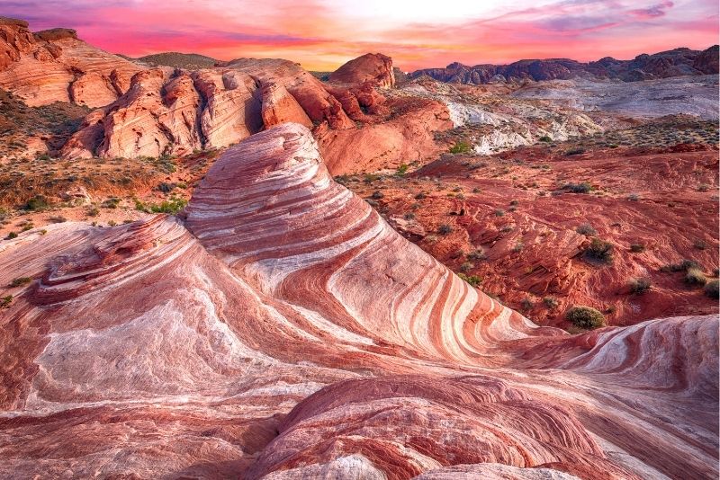
Next up is Rainbow Vista which is an easy 1-mile round trip hike to a stunning panoramic canyon view. The colors here are so beautiful and unusual. Before you head to the next attraction, you have to stop and see the impressive view of Mouse Tank’s Road (White Domes) which has been used in many movies and is the most photographed part of the park. For a photo of the view, you will park in a pull out and climb on top of a rock. To get to this view, pull out from the Rainbow Vista parking lot, drive south on Mouse’s Tank Road (like you are heading out of the park). The road will go downhill and bend to the right. Park in the pullout on the right side of the road and climb the rock for the view. The GPS coordinates of the parking area are 36°26’56.2″N 114°30’56.3″W. This will be a little backtracking, but it is the easiest way to find the pull out and get one of those great pictures.
Once you get your picture here continue north on White Domes Loop and you will come to Fire Canyon Road which is an overlook of Fire Canyon and the Silica Dome. This is only an overlook with no trails here. On your way up to the next areas of interest, there are two parking areas that you can stop to take pictures or just see more of the interesting rock formations in the park.
The next area is a parking area, P3, brings you to 3 more features. The first is Pink/Pastel Canyon. You can see some of this from the parking area, but it best seen on the Fire Wave/Seven Wonders trail. This hike is a little longer, it is a 1.8-mile loop to see colorful formations and small slot canyons. If you only want to see the Fire Wave formation it is 1.5 miles round trip. This formation is not visible from the road. The other hiking trail accessible from P3 is White Domes Loop. This is a 1.1-mile hike that takes you to a slot canyon and remains of 60’s movies set.
Head back to Valley of Fire Road by going south on White Domes Road. When you get to the intersection turn left to see the rest of the features in the park. This will also take you to the west entrance/exit. If you are heading to Las Vegas this is the way you want to go.

Next up is Atlatl Rock, which has the best representation of petroglyphs in the park. This is a short walk from the parking lot to a set of metal stairs that take you close to the petroglyphs. This parking area is not right off of the road, but it is clearly marked how to get here. It will also take you to Arch Rock. At one time this was an arch over some other rocks, but time and erosion weakened it and it fell. You can still drive here and see where the arch was.
Last but not least, are the Beehives Rock Formations. These formations are shaped liked beehives and sort of look like hives on the outside. You can see these from the parking lot, but it is a pretty easy walk to get a closer look at them.

Conclusion
Valley of Fire is one of the most popular state parks in Nevada. The bright red rock intermixed with the varying colors of sandstone and limestone are stunning! The really nice thing is there are so many places to stop for pictures and a lot of the hikes are short, so if you don’t do a lot of hiking you can probably still do a few of them with no problem. Just keep in mind that the trails are over sand and some of the terrain is rough so the hike may seem longer. Keep your limits in mind before you start out. It’s relative closeness, makes it a great place to explore if you’re staying in Las Vegas. We love to share our adventures with people and hope to inspire you to find your own adventure.
If you don’t live near Las Vegas, I hope that you take time to visit some of the natural beauty in your area whether for a day trip or long weekend. Go find your adventure! To see more of our adventures click here:https://youtu.be/TdZyLzm_mPk